DISCLAIMER: all of this project is based on data coming from this recent scientific paper, published in Sept. 2023 (Palladino, G., Prosser, G., Olita, F., Avagliano, D., Dello Iacovo, B., Giano, S. I., … Grimaldi, S.)
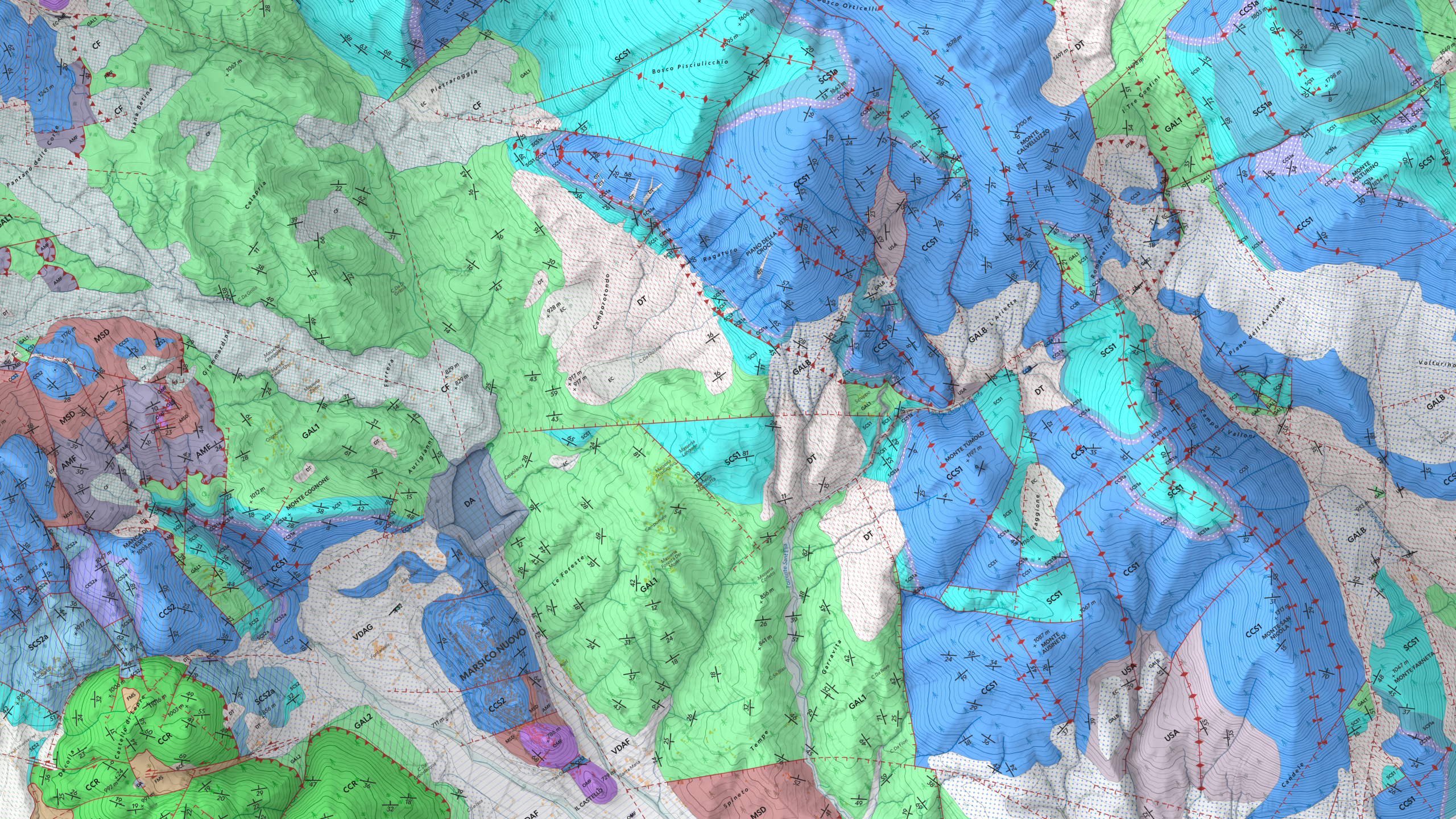
The Val d’Agri 3D Geological Tour project is an interactive experience designed to explore the geology of the Val d’Agri region in Basilicata through an immersive three-dimensional map. This innovative tool allows users to analyze geological details of the area with a visual and dynamic approach, combining technical data with a clear and intuitive representation.
Project Goals
Its main goal is to provide an educational and outreach platform about local geology, integrating complex geological data with advanced graphical representation. Also, this project aims to promote accessibility to highly detailed geological information for students, professionals, and enthusiasts.
Key Features
The strenght and major innovation brought from this project is the ability to convey geological informations much better than a classic 2D geological map. In fact, geological features such as units, formations, faults, folds etc are all three-dimensional entities that are very difficult to explain verbally or by bidimensional supports. With this web map, I decided to go full on 3D Visualization, so that the interactive map allows users to freely explore the morphology and stratigraphy of the region from customizable angles, in order to better visualisize all the complex features of this territory. Moreover, all the data presented in this web map are perfectly equal to the traditional Geological Map produced for this work (available at this link), so you will not find discrepancies or other kind of incorrect informations.
Technologies Used
The project leverages advanced web technologies: primarly, I chose to use extensively MapLibre GL JS, which is a TypeScript library that uses WebGL to render interactive maps from vector tiles in a browser, and guarantees a smooth and interactive map experience. Obviously, to create custom controls and panels, the combo of HTML/CSS/JS is mandatory.
Impact and Applications
This platform holds significant educational and touristic potential, fostering an understanding of the region and highlighting geology as a cultural and scientific resource. Additionally, it can be integrated into research projects or serve as a support tool for territorial planning studies.
Future Plans
I plan to enhance this web map application with more tools, functionalities and data going ahead, so stay up to date and feel free to contact me for feedbacks and possible improvements.